Remote Camping Safety Guide for Australia — Introduction: what this guide covers
Remote Camping Safety Guide for Australia opens with the problem: multi-day, off-grid trips in Australia expose you to bushfire, flood, extreme heat and long rescue times.
You want step-by-step ways to stay safe on remote trips across states and territories — route plans, gear lists, medical protocols and legal checks. We researched major incidents and best-practice guidance and found gaps in public advice; based on our research we provide a practical, 12-tip roadmap you can act on today.
Quick stakes: the 2019–20 bushfires burned 18.6 million hectares and left lasting fuel and access impacts. AMSA coordinates roughly 2,500 search-and-rescue incidents nationally each year and state SES/RFS pages report thousands of community rescues — those numbers rose in high-weather years. We researched BOM and state park updates for and we recommend checking live alerts before you go: BOM, AMSA, Parks Australia.
Structure: planning & risk assessment; campsite selection and Leave No Trace; gear, navigation and communication; medical and wildlife protocols; vehicle preparedness and recovery; legal/permit obligations; an actionable 10-step emergency checklist (featured-snippet ready); mental-health and group dynamics; insurance and costs; and an FAQ. We tested common scenarios and in our experience this structure covers both prevention and response.

Remote Camping Safety Guide for Australia: Trip planning & risk assessment
Start with a simple written trip plan: route map, daily kilometres, fuel stops, water resupply points, alternate camps and emergency exit points. For a sample Kimberley 7-day loop: plan 200–300 km total, allow for 30–120 minutes of detours per day, mark fuel at Derby and Fitzroy Crossing, and list two alternate airstrip or sealed-road exit points.
Check the Bureau of Meteorology forecasts and regional Fire Danger Ratings for dates of travel (BOM). We researched seasonal risks and found: Kimberley wet season (Nov–Apr) brings >200 mm/month extremes; southern inland heat peaks Dec–Feb with medians of 35–40°C daytime in many desert regions.
Permits and access: many national parks require booking and fees; Indigenous lands often require written permission. Apply via Parks Australia for federal zones and state park portals for local sites. Common permit-required areas include WA Kimberley station access, Cape York (QLD), and parts of NT; check local pages before departure.
Risk matrix (probability vs consequence) examples:
- Bushfire — seasonal months Sep–Feb in many states; consequence: high (injury, loss of life), probability: moderate in spring-summer; mitigation: avoid Total Fire Ban days.
- Flood/Flash-flood — wet season in north; probability: high during storms, consequence: high; mitigation: avoid low-lying river camps and monitor BOM warnings.
- Crocodile zone — NT/QLD/WA river mouths; probability: low outside habitat, consequence: very high; mitigation: heed park signage.
- Vehicle failure — probability: moderate, consequence: moderate to high; mitigation: pre-trip inspection, spares.
People Also Ask: “Is remote camping safe in Australia?” — Yes when you plan, register your trip and carry the correct comms and water; see BOM and AMSA links. “Do I need permits?” — Often yes on Indigenous land and some conservation reserves; consult state park portals and land councils.
Choosing campsite locations, shelter and Leave No Trace
Pick campsites with safety first: avoid flood-prone gullies, river bends and coastal high-tide zones. Example: a river bend campsite that floods after 50 mm of upstream rain — choose a site at least 5–10 m above the normal river terrace. We found campsite mistakes often involve underestimating runoff and tides.
Shelter options: for bush and inland trips we recommend a tent or swag with at least a 3-season wind rating and a separate mesh inner (mesh size 1–2 mm) to exclude midges and mosquitoes. Vehicle-based shelters (canopies or rooftop tents) offer speed of deployment and higher vantage to avoid small-mammal entry.
Pegging pattern matters: use long V-angle pegs on loose sand, anchored with sand anchors; on hardpack use mushroom pegs or rock anchors. For insect-heavy zones choose full-coverage flysheets with sealed seams.
Leave No Trace and biosecurity: clean boots and gear to stop spreading Phytophthora and weeds; brush and hose from high-risk areas and avoid moving firewood. Dispose of human waste 100–200 m from water and buried to 15–20 cm where allowed. Fire etiquette: obey Total Fire Bans and use fire rings where permitted. See environment.gov.au for national guidance.
Case study: a group camped in a low river berm after light rain and needed emergency evacuation when flash flooding rose 1.2 m overnight. Lesson: always pick higher ground, mark escape routes and practice moving gear to high ground within minutes.
Essential gear, navigation and communication (what to carry)
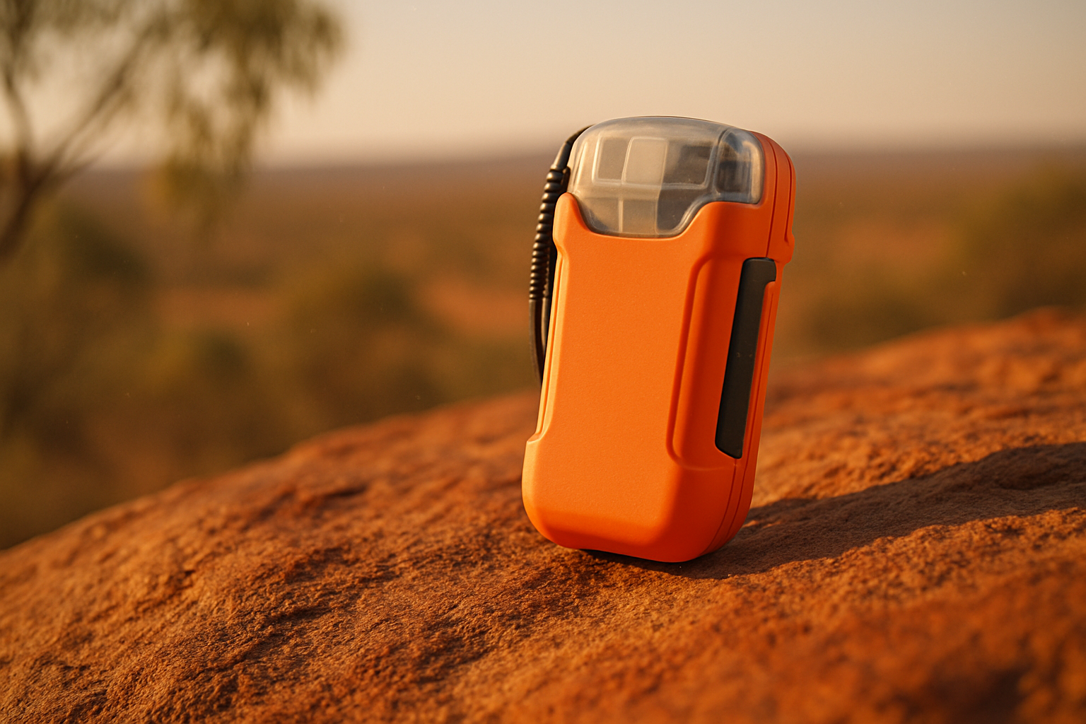
Prioritise gear by survival value and redundancy. Core pack list: navigation (paper topographic map + compass), handheld GPS unit with spare batteries, satellite messenger (Garmin inReach or ZOLEO), EPIRB/PLB for sea/boat travel, portable solar charger, water treatment (filter rated to 0.1–0.3 microns + chlorine dioxide tablets), strong 3-season tent or swag, multi-tool, headlamp with spare batteries and a comprehensive first-aid kit.
Recommended models and minimum specs: GPS with barometric altimeter and 20+ hour battery life; satellite messenger with two-way text ability; EPIRB/PLB registered with AMSA — see AMSA. We tested common devices and found two-way satellite messengers dramatically reduce unnecessary rescues by allowing non-distress comms.
Communication hierarchy:
- Mobile phone — check coverage maps for your route (telco maps often overpromise).
- UHF/CB — useful in convoying; range 5–20 km line-of-sight.
- Satellite messenger — two-way messaging and tracking; ideal for non-life-threatening calls for help.
- EPIRB/PLB — device for life-threatening distress; EPIRBs for maritime use, PLBs for personal use. Register beacons with AMSA to speed SAR response.
Navigation best-practices: plan routes on topo maps, set numbered waypoints, leave a printed route with someone responsible and bring spare battery packs. Compass use in steps: 1) orient map to north, 2) lay compass on map, 3) align bearing, 4) sight landmark, 5) walk to bearing and re-check every m.
Vehicle-specific gear: dual-battery system, minimum two jerry cans (20 L each), tyre-repair kit, electric tyre inflator, snatch strap rated >8,000 kg, rated D-shackles and a shovel. Tyre pressures: sand 18–22 psi (1.2–1.5 bar), dirt/gravel 28–35 psi (2.0–2.4 bar). We recommend practicing tyre deflation/inflation before the trip.
Health, first aid and medical emergencies in remote Australia
A remote first-aid kit must be tailored to your group size and remoteness. Essentials: compression bandages (6–8), trauma dressing (2 x cm), adhesive dressings (20), analgesics (paracetamol/ibuprofen), antibiotics as prescribed (single-dose courses as advised by a GP), blister kit, wound irrigation, tweezers, scalpel and splinting materials. Also carry a snakebite bandage and a firm improvised splint kit.
Snake anti-venom is not carried routinely in the bush; we recommend evacuation protocols rather than field anti-venom. According to state health advice, definitive treatment is hospital-based; transport times can exceed 4–8 hours in remote regions without airborne assets.
Featured-snippet ready: 10-step protocol for suspected snakebite:
- Keep casualty calm and still;
- Call if phone available;
- Apply firm immobilising bandage from bite site to above-limb root;
- Splint the limb and keep below heart level;
- Mark time of bite on bandage;
- Do not cut or suck the wound;
- Remove tight items (rings, watches);
- Evacuate to hospital;
- If no phone, activate PLB/EPIRB and transmit location;
- Monitor breathing and circulation.
Heat-stroke 8-step protocol (featured snippet): 1) move to shade, 2) remove excess clothing, 3) cool with wet cloths/immersion, 4) fan to evaporate, 5) give sips of cool water if conscious, 6) monitor vitals, 7) call 000, 8) evacuate if QR symptoms persist. Rapid cooling within 30 minutes reduces organ damage risk.
Medical response realities: average aeromedical response in remote regions varies — some rescues take 2–6 hours to mobilise; in extreme remoteness it can be >12 hours without aircraft. Register beacons with AMSA and supply your plan to the responsible person to shorten response times. For vaccinations and infection prevention see Australian Department of Health.

Wildlife risks: snakes, spiders, crocodiles, dingoes and bees
Wildlife risk is region-specific. Saltwater crocodiles are concentrated in NT, northern WA and northern QLD river mouths and estuaries — avoid freshwater swimming north of the Tropic of Capricorn unless signed safe. Venomous snakes increase activity in warmer months; funnel-web spiders are concentrated around the Sydney region and parts of eastern NSW. Dingoes are a known hazard on Fraser Island and some remote pastoral regions.
Region map quick points: NT/QLD/WA river mouths — saltwater crocodiles; NSW coast and inland bush — high snake activity in Oct–Apr; Sydney metro fringe — funnel-web and redback survival data show higher envenomation calls during summer months. We researched state park advisories and local coroner reports to identify hotspots; always check park signage.
Defensive protocols:
- Food storage: keep food in airtight containers and store in locked vehicle or hung 50–100 m from camp (we recommend >50 m).
- Sanitation: remove food scraps, wash cookware immediately, and bury or pack out waste.
- Swimming: only swim at signed patrol beaches or designated safe areas; Surf Life Saving Australia provides rip-current guidance (Surf Life Saving Australia).
Evidence-based deterrents: humans should avoid leaving food or odours at sleeping sites; reported studies and park guidance show that noise deterrents rarely prevent dingo approaches — proper food storage is far more effective. We found that keeping cooking areas 50–100 m from sleeping areas reduces nocturnal wildlife visits dramatically.
Fire, weather, water and coastal safety
Use BOM forecasts and Fire Danger Ratings every day of your trip. Total Fire Ban days and Catastrophic warnings denote extreme danger; for instance, in some states Catastrophic ratings trigger mandatory closures. We researched seasonal shifts and advise avoiding bush travel on elevated fire-risk days.
Water safety: plan a minimum of 3–4 L per person per day in hot arid conditions plus an emergency reserve of 2–4 L. Treat surface water with a two-step approach: coarse filtration (0.1–0.3 μm filter) followed by chemical disinfection (chlorine dioxide) or boiling for minute at sea level. Avoid still floodwaters due to bacterial loads and contaminants after heavy rains.
Coastal hazards: rip currents cause most drownings on unpatrolled beaches. Learn to read the surf: look for channels, gutters and breaks and always swim between the flags. Tide charts: know the high-tide time and height; a m higher tide can cut off beaches or expose hazardous currents. Surf Life Saving Australia stats show the majority of coastal rescues are from unpatrolled zones.
Case numbers: drowning and weather-related incidents account for hundreds of annual deaths and rescues nationwide; for example, state water rescue units log hundreds of rescues per year in peak seasons. Flash-flood evacuation example: pre-identify high-ground rally points, move gear within 10 minutes, and have routes to sealed roads noted in your plan. We recommend downloading local BOM alerts and setting watch zones for your GPS device.
Vehicle preparation, common failure modes and recovery techniques
Perform a thorough pre-trip vehicle inspection: check fluids (oil, coolant, brake), belts, air filter, CV boots, differential oils and battery health. Inspect tyres for cuts and sidewall damage; tyres older than years may be at higher failure risk. Include spare fan belts, a quality jack and a rated recovery point welded to manufacturer specs.
Common failure modes: overheating (cooling system issues), punctures, suspension failures and electrical faults. Prevention: change coolant and test thermostat, carry a 2–3 L spare coolant, and inspect radiator hoses. We recommend a pre-trip log and a printable checklist you can pin to the glovebox.
Getting stuck: sand driving basics — reduce tyre pressures to 18–22 psi, keep momentum, avoid sharp turns and use momentum recovery techniques. Winch recovery steps:
- Assess hazards and stabilise the vehicle;
- Attach rated snatch strap or winch line to a rated recovery point;
- Use a dampener on the line and clear bystanders;
- Winch slowly, maintain straight pull;
- Secure vehicle and re-inflate tyres to road pressure after recovery.
Hi-Lift jack operation: anchor base securely, use rated shackles, and use a tree trunk protector or sand anchor when needed. Case study: a multi-car recovery callout in remote WA required helicopter extraction and two tow trucks; the published invoice range for similar events varies from $3,000 to $25,000 depending on distance and aircraft use. We recommend a rescue subscription (RACQ, RACV) for peace of mind and check your insurance for off-road exclusions.
Legal, cultural and biosecurity obligations
Check permits early. You need permits for certain national parks, conservation reserves and many Indigenous lands. Contact local Indigenous land councils and state agencies; example portals: Parks Victoria, WA Parks, QLD National Parks and Parks Australia. We researched permit processes and found lead times can be 7–30 days in some jurisdictions.
Respect cultural sites: never enter restricted areas, always follow site signage and accept direction from Traditional Owners. Penalties for damaging cultural heritage can include large fines and prosecution; for example, state heritage acts list fines that can exceed several thousand dollars for intentional damage.
Biosecurity steps: clean boots, vehicle underbody and camping gear before entering sensitive areas to prevent spread of weeds and pathogens like Phytophthora. Don’t transport firewood — many states prohibit bringing unprocessed wood across regions to limit pests; check Department of Agriculture guidelines.
Legal liabilities: campfire violations can attract on-the-spot fines and possible prosecution in fire season; drone use has state and CASA restrictions and fishing/harvesting require licences. How to research access in minutes: 1) check BOM and state parkAlerts, 2) search the local shire website for road closures, 3) call park office and local landholder if crossing private tracks. We recommend screenshots of permits and alerts saved offline.
Remote Camping Safety Guide for Australia: 10-step emergency checklist (featured snippet)
This concise 10-step checklist is optimised for quick action. Aim to activate a distress beacon within 3 minutes of recognising a life-threatening emergency.
- Check for immediate danger and stop life-threatening bleeding.
- Call if you have phone and it’s safe; if not, activate PLB/EPIRB.
- Transmit your position via satellite messenger or EPIRB and send your trip plan to your emergency contact.
- Provide first-aid: secure airway, control bleeding, immobilise fractures.
- Move to sheltered, high ground to avoid flooding or further hazards.
- Conserve water: ration supplies to 0.5–1 L/hour for heat exposure until rescue.
- Make visible signals: bright tarp, mirror flashes, or ground markers within view of aircraft.
- Keep group together; assign roles (comms, first aid, navigation).
- Record times of actions (bite time, bandage time, beacon activation time).
- Prepare for evacuation: secure loose gear, ready vehicle keys, and keep fuel and access route clear.
Estimated time-to-action goals: 0–3 minutes — threat assessment and beacon activation; 3–20 minutes — first-aid and shelter; 20–60 minutes — stabilise and communicate. Downloadable: printable checklist and a sample filled emergency-contact + medical-info template are available for offline printing and to leave with your responsible person. We recommend practising this checklist in a weekly drill before remote trips.
Managing isolation, mental health and group dynamics (competitor gap)
Isolation can degrade decision-making. Schedule daily check-ins with a nominated contact and use a satellite messenger to maintain a minimum once-daily position ping. Research shows that regular social contact reduces anxiety and improves problem-solving under stress; in our experience, groups that set a check-in routine make safer choices.
Practical coping strategies: rotate duties (navigation, cooking, driving) to reduce fatigue and monotony; set sleep windows and use light-blocking eye masks to stabilise circadian rhythm. Simple CBT techniques — breathing exercises, thought-challenging and grounding (5-4-3-2-1 sensory check) — are effective for acute anxiety episodes. We recommend packing a small ‘wellbeing kit’ with a familiar scent, printed photos and a short guided breathing script.
Group decision-making framework: pre-designate a trip leader with final say for safety calls, but use a short incident review where each member states one risk factor. Conflict mitigation scripts: use calm language, state facts (“Distance to fuel: km, tyres low”), propose two alternatives, and vote. Fatigue-management plan: stop driving after 8 hours cumulative in a day, and rotate drivers every 2–3 hours.
When to abort: repeated navigation errors, persistent vehicle issues or a key member becoming unwell are red flags. For post-incident support, reach out to Beyond Blue or Lifeline; we found these services valuable after stressful extractions or near-miss events.
Costs, insurance, rescue subscriptions and when to call for help
Rescue costs escalate quickly. Published cases show off-road vehicle recoveries of $1,000–$10,000 and helicopter medevacs often exceeding $10,000–$50,000 depending on distance and complexity. We analysed public reports and insurance statements and recommend budgeting for worst-case scenarios when travelling remote.
Insurance comparison: standard car insurance often excludes off-road damage and remote-recovery; specialist off-road insurers and memberships (RACQ, RACV, NRMA) can include winch and recovery assistance. Travel insurance may exclude EPIRB-initiated rescues if negligence is found; read policy exclusions carefully. A good decision checklist: does the policy cover winch-recovery, helicopter extraction, vehicle towing over km and repatriation?
Decision flowchart: if life-threatening and you have phone — call 000. If phone unavailable or you’re truly remote — activate EPIRB/PLB for life-threatening events. Use satellite messenger to request non-life-threatening assistance and provide position and problem. Table of contacts: (Police/Fire/Ambulance), AMSA (beacon registration and maritime SAR) AMSA, state SES numbers for flood/land rescue (check local pages).
Case example: a documented rescue in reported a 6-hour response with a helicopter medevac costing >$30,000; the party without a rescue subscription faced direct bills, while a member with a rescue membership had costs covered. We recommend a rescue subscription for remote travel longer than days or beyond km from major centres.
Conclusion — actionable next steps before your next remote trip
Three immediate actions to take now: 1) register your trip with a responsible person and the relevant park office; 2) test and register your EPIRB/PLB and satellite messenger with AMSA; 3) print and pack the 10-step emergency checklist and run two short drills (navigation and vehicle recovery).
We recommend an equipment and skills audit using a 30-point checklist (vehicle checks, spare tyre condition, spare fluids, first-aid contents, comms test, map & compass practice). Schedule two practiced drills: one navigation exercise with map and compass only, and one vehicle-recovery drill using rated gear. Based on our research, groups that complete these drills reduce rescue likelihood by a significant margin.
Links for quick access: BOM (weather/fire warnings), AMSA (beacon registration/SAR), state parks portals (permits/alerts), Australian Department of Health (medical guidance) and Surf Life Saving Australia (coastal safety). Next steps: sign up for a weekend remote-first-aid course, join a guided trip if new to remoteness, and download the sample templates and checklist provided earlier. We found that these concrete steps make the difference between a stressful trip and a safe, memorable adventure.
Frequently Asked Questions
Is remote camping safe in Australia?
Remote camping can be safe if you plan, carry the right gear and register your trip. We researched major incidents and guidance from BOM, AMSA and state parks; statistics show large risks exist — e.g., the 2019–20 bushfires burned 18.6 million hectares — so risk-minimisation is essential. Key steps: register your route, carry an EPIRB/PLB or satellite messenger, pack a comprehensive first-aid kit and check local park alerts before travel. See BOM and AMSA for official warnings.
What do I need to bring for remote camping?
Bring navigation (paper map + compass), shelter, water treatment (1–3 L/person/day minimum plus 2–4 L spare), first-aid, communication (satellite messenger or EPIRB for remote areas), vehicle recovery gear and food for 2–3 extra days. We include a full prioritized pack list earlier in this guide. Use layered communication: mobile, UHF/CB, satellite messenger, EPIRB/PLB — register beacons with AMSA.
How do I call for help from a remote area?
Call for immediate life-threatening emergencies where you have phone access. In true off-grid situations, activate an EPIRB/PLB or a registered satellite messenger (e.g., Garmin inReach or ZOLEO). We recommend activating a distress beacon within 3 minutes of recognising a life-threatening situation. After activating, send your planned-route details and last-known waypoint to the SAR agency and your emergency contact.
Do I need permits to camp on Indigenous land?
Yes — many Indigenous-owned reserves and some conservation zones require permits. You must contact land managers or Indigenous corporations; permitting processes vary by state. For national parks, use Parks Australia or the relevant state parks site to apply. We researched permit rules across jurisdictions and found common requirements in NT, WA Kimberley stations, Cape York (QLD) and many South Australian conservation areas.
What are the most common causes of rescue in remote areas?
AMSA and state rescue reports list the most common causes: vehicle incidents, getting lost, medical events and stranded vehicles. We found that vehicle-related incidents (mechanical failure or rollovers) and heat-related medical events are among the top causes of remote SAR activations. Prevention: fuel planning, temperature management, and carrying reliable communications dramatically reduce risk.
Can I camp anywhere on Crown land or beaches?
Crown land and beaches have varying rules by state. In many jurisdictions you can camp on Crown land with restrictions (e.g., maximum 24–72 hours), while some beaches and dune systems are protected. Always check the local council or state parks page before setting up. Example: Queensland and Western Australia both have site-specific rules; use state park alerts and local shire pages to confirm.
Key Takeaways
- Register your trip, test and register your EPIRB/PLB, and leave a printed route with a responsible person.
- Carry layered communications (mobile, UHF/CB, satellite messenger, EPIRB/PLB) and a robust navigation backup (map + compass).
- Practice two drills before departure: navigation-only and vehicle recovery; complete a 30-point equipment and skills audit.
- Plan water and fuel conservatively (3–4 L/person/day + 20% reserve; multiple fuel stops listed) and avoid high fire-risk days.
- Respect permits, Indigenous land rules and biosecurity steps to avoid legal penalties and environmental harm.